


Taylor TWP Voting District, Columbia County, Arkansas
About
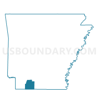
Outline

Summary
| Unique Area Identifier | 526189 |
| Name | Taylor TWP Voting District |
| County | Columbia County |
| State | Arkansas |
| Area (square miles) | 97.44 |
| Land Area (square miles) | 97.43 |
| Water Area (square miles) | 0.00 |
| % of Land Area | 100.00 |
| % of Water Area | 0.00 |
| Latitude of the Internal Point | 33.14120440 |
| Longtitude of the Internal Point | -93.43882010 |
Maps


Graphs
Select a template below for downloading or customizing gragh for Taylor TWP Voting District, Columbia County, Arkansas


Neighbors
Neighoring Voting District (by Name) Neighboring Voting District on the Map
- Emerson TWP Voting District, Columbia County, AR
- Magnolia Northwest Voting District, Columbia County, AR
- Magnolia Southwest Voting District, Columbia County, AR
- Mars Hill Voting District, Lafayette County, AR
- Oak Grove Voting District, Lafayette County, AR
- Precinct 1, Webster Parish, LA
- Precinct 2, Webster Parish, LA
- State Line Voting District, Lafayette County, AR
- Taylor City Voting District, Columbia County, AR
- Walker Creek Voting District, Lafayette County, AR
Top 10 Neighboring County Subdivision (by Population) Neighboring County Subdivision on the Map
- Magnolia township, Columbia County, AR (16,504)
- District 1, Webster Parish, LA (3,530)
- District 4, Webster Parish, LA (3,344)
- Emerson township, Columbia County, AR (1,891)
- Taylor township, Columbia County, AR (1,596)
- Hadley township, Lafayette County, AR (1,027)
- Walker Creek township, Lafayette County, AR (589)
- Mars Hill township, Lafayette County, AR (157)
Top 10 Neighboring Place (by Population) Neighboring Place on the Map
Top 10 Neighboring Unified School District (by Population) Neighboring Unified School District on the Map
- Webster Parish School District, LA (41,207)
- Magnolia School District, AR (17,186)
- Lafayette County School District, AR (5,731)
- Emerson-Taylor School District, AR (3,429)
- Bradley School District, AR (2,342)
Top 10 Neighboring State Legislative District Lower Chamber (by Population) Neighboring State Legislative District Lower Chamber on the Map
Top 10 Neighboring State Legislative District Upper Chamber (by Population) Neighboring State Legislative District Upper Chamber on the Map
- State Senate District 36, LA (119,479)
- State Senate District 21, AR (74,633)
- State Senate District 26, AR (68,899)
Top 10 Neighboring 111th Congressional District (by Population) Neighboring 111th Congressional District on the Map
Top 10 Neighboring Census Tract (by Population) Neighboring Census Tract on the Map
- Census Tract 9503, Columbia County, AR (5,088)
- Census Tract 313, Webster Parish, LA (5,013)
- Census Tract 312, Webster Parish, LA (2,924)
- Census Tract 4702, Lafayette County, AR (2,917)
Top 10 Neighboring 5-Digit ZIP Code Tabulation Area (by Population) Neighboring 5-Digit ZIP Code Tabulation Area on the Map
- 71753, AR (16,848)
- 71075, LA (6,416)
- 71770, AR (3,526)
- 71860, AR (2,633)
- 71861, AR (2,258)
- 71740, AR (1,735)